Arte Sella is an international exhibition of contemporary art which began life in 1986. It takes place in the open, in the fields and woods of the Sella Valley (Borgo Valsugana municipality, in the Province of Trento).

Since 1996 the Arte Sella project has been laid out along a path in the woods on the southern slope of the Armentera Mount. The ideal route, named ARTENATURA (“Art in Nature”) which has taken shape in this way is designed to enable visitors to observe the works of art and at the same time to enjoy the natural site itself with its different types of woods, rocks and monumental trees.

The idea of the exhibition is not just to display works of art but also to show the creative process involved in them: the works are followed day by day in their development as they are created and the artists are called upon to express their respectful relationship with nature from which they draw inspiration.

The works are usually three-dimensional since they are created using stones, leaves, branches and tree-trunks; occasionally man-made objects, materials or colours are also used. When the exhibition closes, many of the artworks are left to decay, thus becoming part of nature’s life-cycle; others are put on show in museums, art galleries and exhibitions in Italy and abroad.

In the last few years Arte Sella has expanded to the nearby Malga Costa (Costa shepherd’s hut). This unusual but attractive building has been the setting of several exhibitions, events and creative workshops which have attracted considerable interest and have rendered the shepherd’s hut an effective experimental and exhibition area.

Borgo Valsugana can be reached from national road SS.47. It is about 35Km from Trento and 100 Km from Padua.

The nearest airports are „Catullo“ in Verona and „Marco Polo“ in Venice.
A bus service connects both airports to the railway stations of Verona Porta Nuova and Venezia S.L.

Borgo Valsugana can also be reached by taking the Trento-Venice train line.
The Sella Valley is about 7Km from Borgo Valsugana, about 800 meters above sea level.

Parking area:
- locality Carlon: 50 car parks (a charge is levied for their use from June until September);
- other free car parks along the Valley.

Free shuttle bus service:
Every Sunday between June 1rd and September 30th a free shuttle bus service is at your disposal from 10:00 a.m. to 6:30 p.m. The bus stops at the Osteria al Legno and at the Carlon car park.

If disabled people are on board, the bus will continue its run as far as Malga Costa (Costa shepherd’s hut area).
The first run will stop at the Borgo Valsugana Est station (9:30 a. m.).

No bus transit:
Due to the remarkable traffic flow in the Sella Valley during the summer months of July and August, the Borgo Valsugana town council prohibits any bus transit from Soggiorno Val Paradiso to the Carlon area on Saturdays and holidays, with the exception of the authorized ones. The authorization must be required at the Borgo Valsugana municipal police station.
-->
Screenshots.


-->


Crea le tue foto ed immagini come Slideshow per eBay, Netlog, MySpace, Facebook o la tua Homepage!Mostrare tutte le immagini di questo Slideshow


Custom Search

www.zanox.com

If you liked this article, subscribe to the feed by clicking the image below to keep informed about new contents of the blog:
0
In order to understand the present day Levanto, we must behave like we do with the people we love: learn its story, give a historical depth to the landscape of today and learn about the vocations and the identities that have followed one another in time.

We can distinguish at least three of them:

- the feudal and agricultural-pastoral identity of the Bardellone mountain, which is linked to the contrai of the passes and the Communications by land, as well as to the centres of Ceula and Zolasco that have now vanished;

- the communal and mercantile-maritime identity, which is centred around the village of Levante and experienced through a complete devotion to the Republic of Genoa but not without feeling the great importance of the agricultural economy: from the charm of the agriculture of the villa to the constellation of the rural centres in the valley;

- the tourist identity, which takes piace in two different periods and according to two different models: a type of tourism reserved for the élite (until the 1950's) and one for the mass (after the 1950's).

The first mode! offers, especially to tourists coming from abroad, the refined image of a sub-stantially rural Levante, placed in the middle of a rural landscape that, according to the impressions of the first tourists, was considered a great garden, a sort of paradise on earth.

The second model, instead, offers the image of a Levante) that turns its back onte its territory and concentrates on the coastal plain and on the Ghiararo (where many gardens tend to disappear), on the beach and on the sea.

This is the model that creates a split not only with regard to the past but with the land as well. The previous models had, in fact, developed without any discontinuity and without any real imbalance between thè coast and the hinterland, between the Village and the Vailey, between urban-isation and territory.

The colonisation of tourists forces to comply with urban models and styles that have no connection with the environment and it trans-forms thè rural landscape and the traditional seats linked to it into mere building ground.

This is what takes piace in thè area around the village of Levante, where the building pressure, especially during thè 50's and 70's, is greater, while the settlement System of the Vailey is stili able to hold on to its urban configuration.

Today, this phase has been overcome: we look to the history and to the future of Levante holding on to ideas and principles that acknowledge economie value to the landscape, to cultural-historical territory, to its historical identity.


Crea le tue foto ed immagini come Slideshow per eBay, Netlog, MySpace, Facebook o la tua Homepage!Mostrare tutte le immagini di questo Slideshow

Custom Search
 
If you liked this article, subscribe to the feed by clicking the image below to keep informed about new contents of the blog:


0
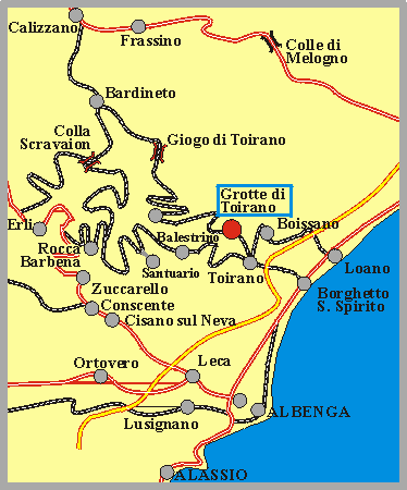
The Toirano Caves (Italian: Grotte di Toirano) are a remarkable karst cave system located in the municipality of Toirano, in the province of Savona, Liguria.

They are some remarkable show caves of Italy and one of the most notables of the region.

The area is situated close to the town of Toirano and few kilometers to the Ligurian Ponente Riviera.

The exit "Borghetto Santo Spirito" of A10 motorway dists 5 km from the caves. One of the most important caves is "Basura", discovered in 1950, and shelter of the Cave bear.

The Grotte di Toirano are located in a karst area at the end of the Vallone del Vero (valley of truth). More than 70 caves are known in this area. As the plural in the name shows, there are several different caves. The whole system consists of the caves Grotta della Bàsura, Grotta della Strega (Witches cave), Grotta del Colombo (Pigeons Cave), and Grotta di S. Lucia (Cave of St Lucia). The show caves are two of the caves, the Grotta della Bàsura with its prehistoric remains and the lower level of the Grotta di S. Lucia. Both are connected by an artificial tunnel.

During prehistoric times the cave was once visited by prehistoric man, probably 12,000 years ago. Very interesting are the hand and foot prints from Neanderthals, many of the handprints are of children. Other remains found in the cave were graves and amphoras from the time of the late Roman Empire. A building at the parking lot of the caves contains the Museo Preistorico della Val Varatella, the prehistoric museum of the Varatella valley. The findings from the caves are on display here.

Another cave visitor was the cave bear (Ursus spelaeus). They left traces like footprints and scratches from their paws. And of course some died in the cave and left their bones in the Cimitero degli Orsi (bear cemetary). A complete skeletton was reconstructed and is on display in the cave.

But the prehistoric remains are not the main sight of this place, much more impressive are the speleothems, which are unique and impressive. The Antro die Cibele, the final chamber of the Grotta della Bàsura, is filled with bulbous calcite conretions, looking like aubergines or melons. Sometimes they remember a bunch of hanging penises, a comparison you wont hear on the tour.... This passage of the cave was still waterfilled when it was discovered, but the water was drained by the construction of the tour path. And so calcite concretions, which form over a very long time in carbonate rich water, which is completely undisturbed.

After this treasure the path enters the artificial tunnel to the final chamber of the Grotta di San Lucia Inferiore. And here the spelethemes are completely different, but still as exceptional as those before. They are mostly fragile and pointy aragonite crystals of exceptional size and number. After this the remaining chambers, offering a wealth of dripstone speleothems, are not appropriately appreciated by the visitors which are overwhelmed by the things they have seen before.

But this place has even more caves for the visitor. There is Grotta di S. Lucia, the upper level of the show cave with a medieval cave church in the entrance. Unfortunately the cave and church are closed most of the time, but it is possible to see the church portal. On the way to this cave a steep trail branches off, which leads to the Grotta del Colombo. This trail includes some iron ladders and climbing, until the visitor reaches the cave entrance. The view is impressive, but the cave itself is closed by a iron bar gate.


Imagehosting at Imageloop

Imagehosting at Imageloop


Imagehosting at Imageloop

Imagehosting at Imageloop

Imagehosting at Imageloop

Imagehosting at Imageloop


Imagehosting at Imageloop

Imagehosting at Imageloop

Imagehosting at Imageloop


Crea le tue foto ed immagini come Slideshow per eBay, Netlog, MySpace, Facebook o la tua Homepage!Mostrare tutte le immagini di questo Slideshow


Custom Search

www.zanox.com

If you liked this article, subscribe to the feed by clicking the image below to keep informed about new contents of the blog:
0
The Leaning Tower of Pisa or simply the Tower of Pisa is the campanile, or freestanding bell tower, of the cathedral of the Italian city of Pisa. It is situated behind the Cathedral and is the third oldest structure in Pisa's Cathedral Square (Piazza del Duomo) after the Cathedral and the Baptistry.

Although intended to stand vertically, the tower began leaning to the southeast soon after the onset of construction in 1173 due to a poorly laid foundation and loose substrate that has allowed the foundation to shift direction. The tower currently leans to the southwest.

The height of the tower is 55.86 m (183.27 ft) from the ground on the lowest side and 56.70 m (186.02 ft) on the highest side. The width of the walls at the base is 4.09 m (13.42 ft) and at the top 2.48 m (8.14 ft). Its weight is estimated at 14,500 metric tons (16,000 short tons). The tower has 296 or 294 steps; the seventh floor has two fewer steps on the north-facing staircase. Prior to restoration work performed between 1990 and 2001, the tower leaned at an angle of 5.5 degrees, but the tower now leans at about 3.99 degrees.This means that the top of the tower is 3.9 metres (12 ft 10 in) from where it would stand if the tower were perfectly vertical.

Timeline.

* On January 5, 1172, Donna Berta di Bernardo, a widow and resident of the house of dell'Opera di Santa Maria, bequeathed sessanta soldi or "sixty coins" to the Opera Campanilis petrarum Sancte Marie. This money was to be used toward the purchase of a few stones which still form the base of the bell tower today.
* On August 9, 1173, the foundations of the Tower were laid.
* Nearly four centuries later Giorgio Vasari wrote : "Guglielmo, according to what is being said, in [this] year 1174 with Bonanno as sculptor, laid the foundations of the belltower of the cathedral in Pisa."
* Another possible builder is Gerardo di Gerardo. His name appears as a witness to the above legacy of Berta di Bernardo as "Master Gerardo", and as a worker whose name was Gerardo.
* A more probable builder is Diotisalvi, because of the construction period and the structure's affinities with other buildings in Pisa. But he usually signed his works, and there is no signature by him in the belltower.
* Giovanni di Simone was heavily involved in the work of completing the tower, under the direction of Giovanni Pisano, who at the time was master builder of the Opera di Santa Maria Maggiore. He could be the same Giovanni Pisano who completed the belfry tower.
* Giorgio Vasari indicates that Tommaso di Andrea Pisano was the designer of the belfry between 1360 and 1370.
* On December 27, 1233 the worker Benenato, son of Gerardo Bottici, oversaw the continuation of the construction of the belltower.
* On February 23, 1260 Guido Speziale, son of Giovanni, a worker on the cathedral Santa Maria Maggiore, was elected to oversee the building of the Tower.
* On April 12, 1264 the master builder Giovanni di Simone and 23 workers went to the mountains close to Pisa to cut marble. The cut stones were given to Rainaldo Speziale, worker of St. Francesco.


Crea le tue foto ed immagini come Slideshow per eBay, Netlog, MySpace, Facebook o la tua Homepage!Mostrare tutte le immagini di questo Slideshow


Custom Search

www.zanox.com

If you liked this article, subscribe to the feed by clicking the image below to keep informed about new contents of the blog:
0
Mi Ping en TotalPing.com follow us in feedly